


11 Rivers Forced Underground
From London to Vienna, Hartford to New York, these rivers were buried by developers, permanently changing the landscape.
This story is part of a special National Geographic News series on global water issues.
Rivers are the lifeblood of many plant, animal, and human communities. Yet many of the world's rivers have been dammed, degraded, polluted, and overdrawn at alarming rates.
Some of the world's great rivers, from the Colorado to the Indus, don't always reach their ends because people have diverted so much water for agriculture, industry, and municipal uses. Other rivers have been completely covered over by development, as people attempted to "tame" nature by ending flooding and maximizing usable land area.
But what happens to once-thriving freshwater ecosystems when the rivers they depend on are entombed in sewer pipes beneath layers of concrete and soil? Few species can make the transition to subterranean living. Ironically, it was often rivers and streams that attracted people in the first place, but those very sources of life can fall victim to the expanding concrete jungle.

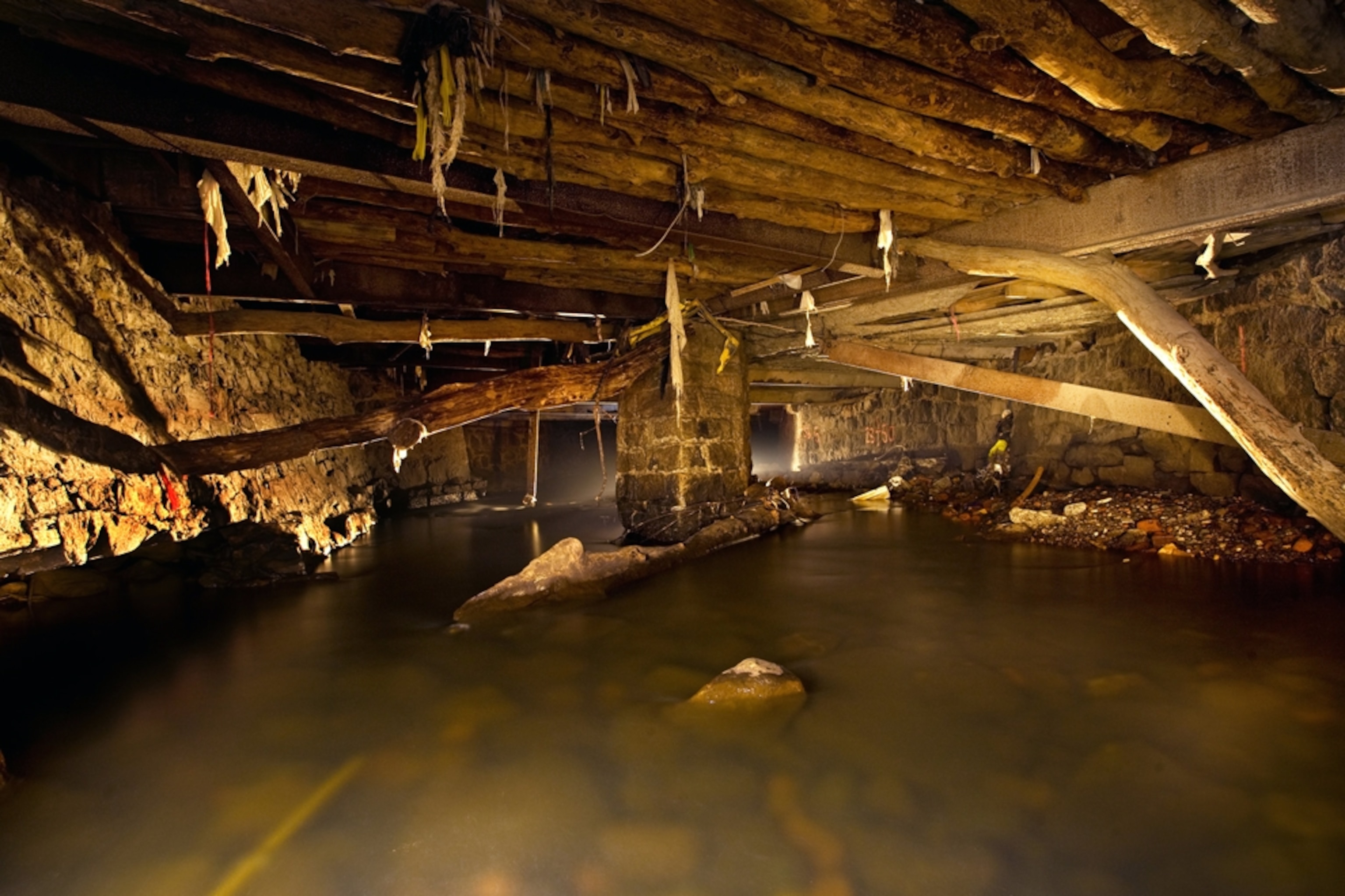
Sunswick Creek, New York City
Sunswick Creek in the Queens neighborhood of New York City fell prey to expanding concrete in the late 1800s. Appearing on maps in the 1870s, Sunswick Creek was soon completely covered over. Now, it exists only as a meager flow through buried sewer-like pipes, as documented in this photo by Steve Duncan. Duncan notes that the burial process appears to have occurred in multiple phases, based on his explorations of the dank channels.

Tibbets Brook, New York City
Tibbetts Brook starts just north of the Bronx and then flows into the borough's leafy Van Cortlandt Park, where it fills a small lake. Thanks to historic development, the brook is then forced underground at Tibbett Avenue.
It then flows under the Bronx through a large, double-channeled brick sewer until it reaches the Harlem River Ship Canal, which was dug in the 1890s, shaping the border with Manhattan.
Before development, the Lenape Native Americans who lived in the area took advantage of the brook's freshwater and plentiful fish and game, which included muskrats, raccoons, rabbits, skunks, and many species of birds. The Lenape called the stream Mosholu, meaning "smooth or small stones."
In the 1690s, property owner Jacobus Van Cortlandt built the small dam that created the lake, in order to power a sawmill and gristmill. He also cut ice from the lake in winter to sell to locals. The city of New York acquired the land that became Van Cortlandt Park in 1888.
Today only a small part of Tibbetts Brook remains above ground. Runoff of toxins from the surrounding city remains a problem for water quality. In 1961, pollution seeped into the stream, leading to the death of thousands of fish in the lake.

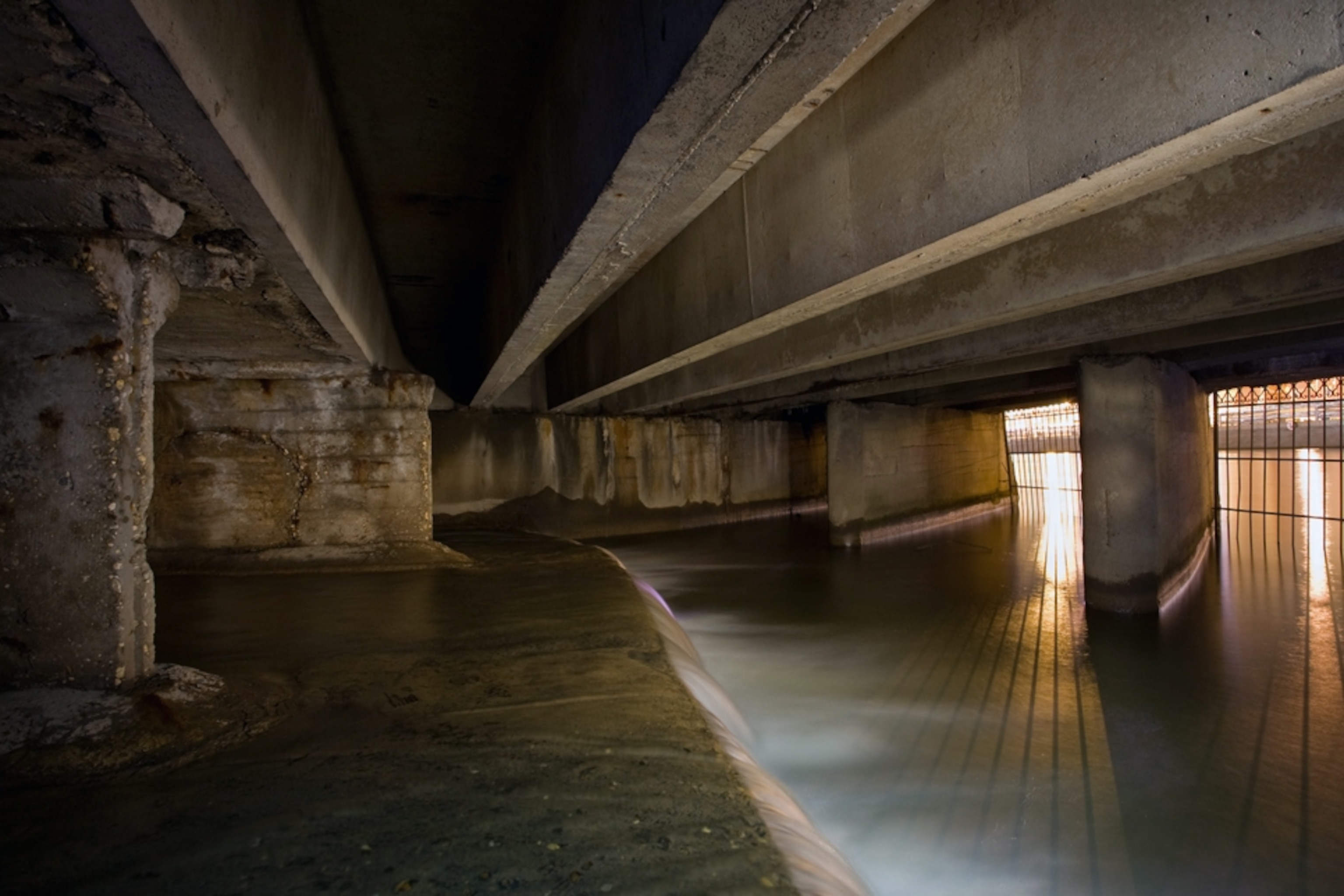
Sawmill River, Yonkers, New York
A tributary of the mighty Hudson River, the Sawmill River flows about 23 miles (37 kilometers) from Chappaqua, New York, to Yonkers, just north of New York City. Since the early 1900s, the last 2,000 feet (600 meters) of the river have been entombed in a flume underneath downtown Yonkers.
The river was covered gradually. First, bridges were built across it. Over time, the bridges got bigger and closer together, as Yonkers experienced rapid industrialization. Eventually, the river was completely covered over, and it has historically suffered from pollution and intense development.
In 2007, a $34 million plan was approved to expose, or "daylight" much of the buried section of the Sawmill River, as part of a $3 billion redevelopment project for Yonkers. This will include a new city park.
Scientists hope that exposing the river to daylight will help restore it to a better state of health. A BioBlitz was conducted in 2009 to assess the health of the watershed. Participants counted eight species of fish, though more than 20 were counted by scientists in the past. Native Americans called the Sawmill the "Great Fishing Trap."

Park River, Hartfod Connecticut
In the 1940s, the U.S. Army Corps of Engineers diverted the Park River beneath Hartford, Connecticut, in what was one of the largest and most expensive projects the Corps had tackled up to that point. The Park had connected the city's west side to the larger Connecticut River, though it had long been abused as a dumping ground for sewage and industrial waste.
Long called Hog River because of its stench, the Park was buried 30 to 50 feet below the surface, where it still runs under the state capitol and main public library.
Today, a few intrepid urban explorers paddle canoes down the buried river. John Kulick of Huck Finn Adventures, who has guided float trips through the subterranean section, told the New York Times he has seen eels, carp, and stripers in the dark water. Kulick joked, perhaps at least half seriously, that a burst of water gurgled into the river because "someone flushed a toilet."

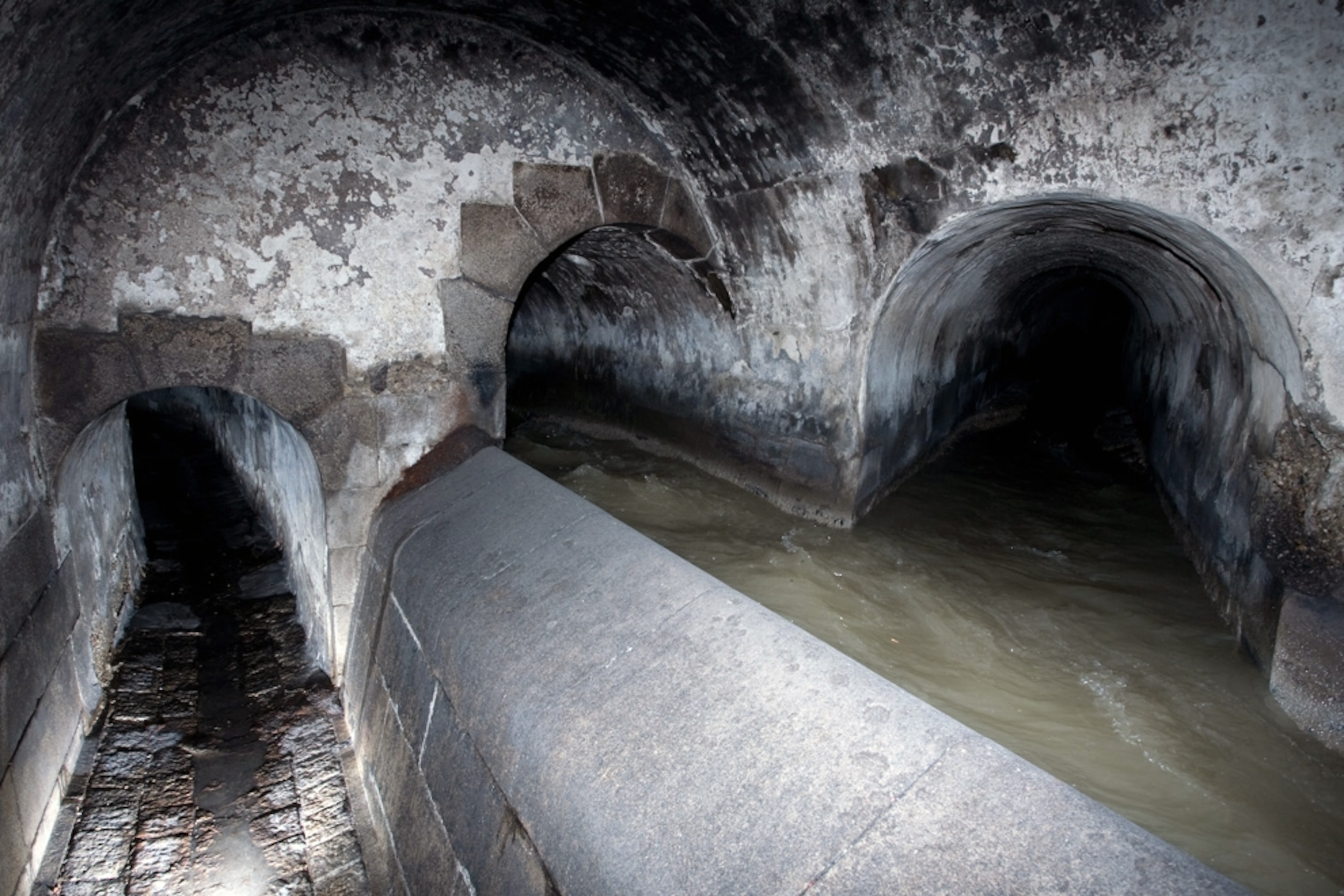
Neglinnaya River, Moscow
The Neglinnaya River (also called the Neglinka River) used to flow across Moscow from north to south, until it was buried underground in 4.7 miles (7.5 kilometers) of tunnels. Today it drains into the Moskva River via two openings.


The Kremlin was built on a hill west of the Neglinnaya River, with a moat filled from its channel. Over time residents grew weary of the river's flooding, so in 1792, the city diverted its course into a new canal, and filled in the original bed. After a devastating fire in 1812, the river became heavily polluted, so engineers covered it over with a vault.
In subsequent decades, additional tunnels were built or expanded.

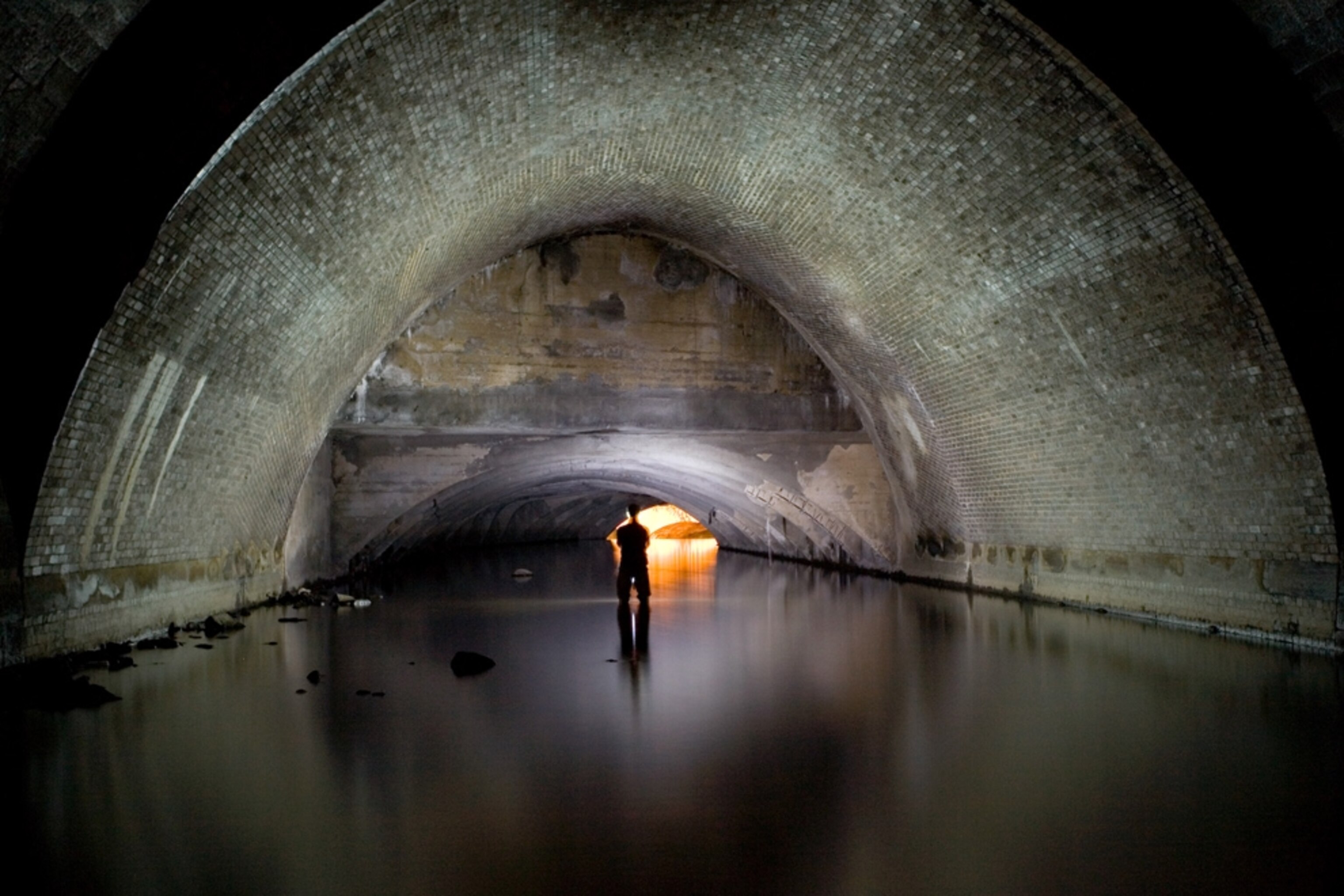
Wein River, Vienna
The Wein River was driven below Vienna long ago, where it was integrated into the city's sewer system. Fans of classic movies may recognize this tunnel from the 1949 Orson Welles film The Third Man, set in postwar Vienna.

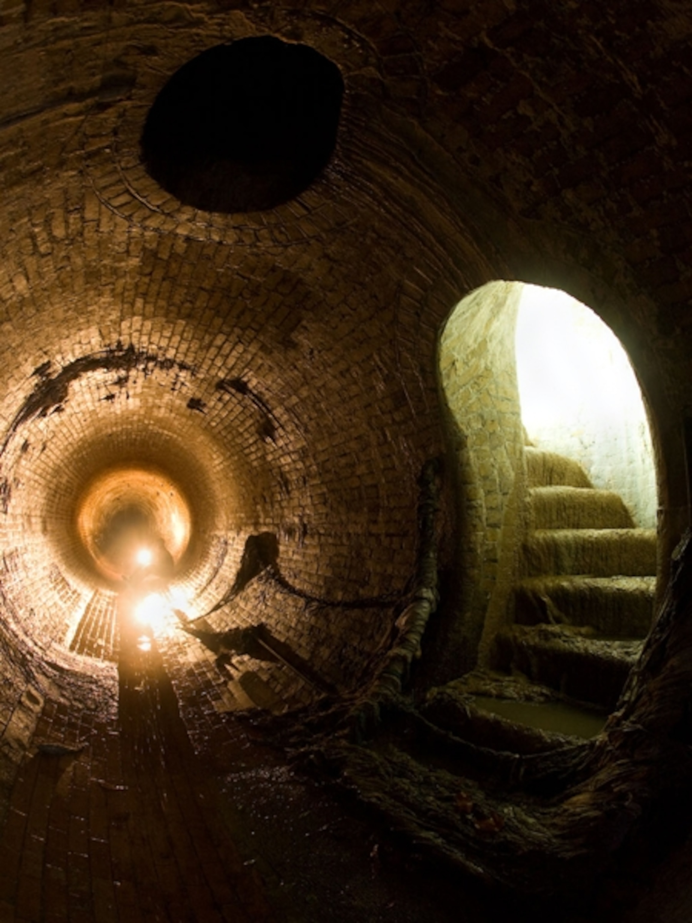
Bradford Beck River, London
Beautiful arched foundations can be seen along the underground Bradford Beck River in Bradford, England. Urban explorer and photographer Steve Duncan believes this section underlies Bradford City Hall, a Victorian-era structure built in the 1880s. (Duncan has traveled the world in search of subterranean rivers.)
According to Duncan, the Bradford Beck flows about four miles through a wide variety of tunnel architecture and building foundations.

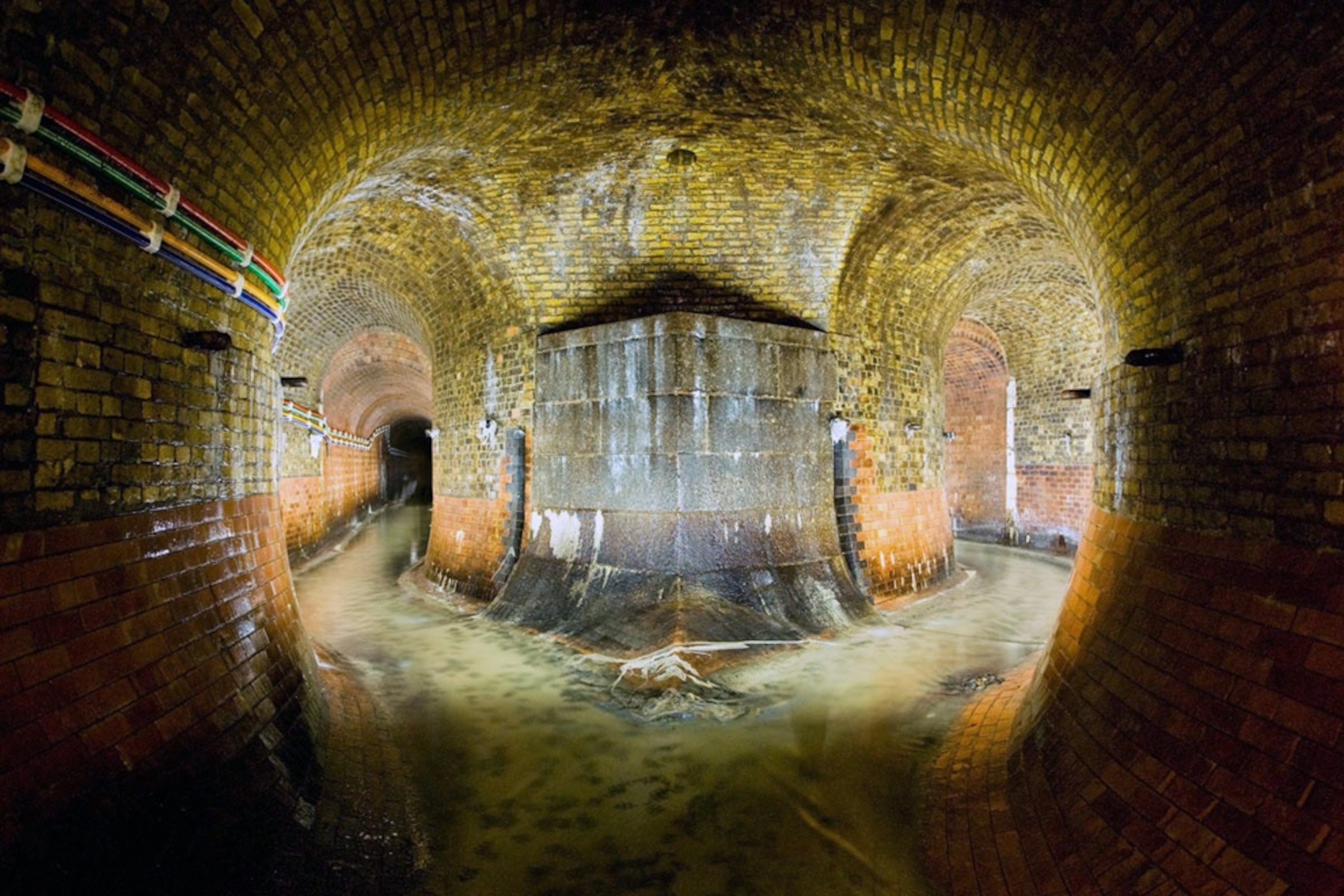
River Sheaf, Sheffield, England
This large area is the end of the tunnel that contains the River Sheaf as it travels through the city of Sheffield. The river emerges from time to time as it passes beneath the city, before it merges with the River Don near Blonk Street Bridge.
The River Sheaf historically suffered severe pollution from industrial activities in the area, especially metalworks, although recent efforts have been made to improve water quality.

River Westbourne, London
A number of watercourses through London were buried over the centuries, including the River Westbourne, which flowed from Hampstead through Hyde Park to Sloane Square and into the River Thames at Chelsea.
The River Westbourne had been an important source of drinking water for the growing city, and conduits were built for that purpose in 1437 and 1439. However, by the 19th century, the water had become too filthy to use for anything except a sewer.
In the early part of the 19th century, the River Westbourne was channeled into underground pipes to make more room for the growing areas of Chelsea, Paddington, and Belgravia. That work was completed in the 1850s, and the river has remained "lost" ever since.
Part of the original iron pipe can still be seen running above the Sloane Square tube station, where it survived intense bombing by Germany in World War II.
Related Topics
You May Also Like


Go Further
Animals
- How can we protect grizzlies from their biggest threat—trains?How can we protect grizzlies from their biggest threat—trains?
- This ‘saber-toothed’ salmon wasn’t quite what we thoughtThis ‘saber-toothed’ salmon wasn’t quite what we thought
- Why this rhino-zebra friendship makes perfect senseWhy this rhino-zebra friendship makes perfect sense
- When did bioluminescence evolve? It’s older than we thought.When did bioluminescence evolve? It’s older than we thought.
- Soy, skim … spider. Are any of these technically milk?Soy, skim … spider. Are any of these technically milk?
Environment
- Are the Great Lakes the key to solving America’s emissions conundrum?Are the Great Lakes the key to solving America’s emissions conundrum?
- The world’s historic sites face climate change. Can Petra lead the way?The world’s historic sites face climate change. Can Petra lead the way?
- This pristine piece of the Amazon shows nature’s resilienceThis pristine piece of the Amazon shows nature’s resilience
- Listen to 30 years of climate change transformed into haunting musicListen to 30 years of climate change transformed into haunting music
History & Culture
- Meet the original members of the tortured poets departmentMeet the original members of the tortured poets department
- Séances at the White House? Why these first ladies turned to the occultSéances at the White House? Why these first ladies turned to the occult
- Gambling is everywhere now. When is that a problem?Gambling is everywhere now. When is that a problem?
- Beauty is pain—at least it was in 17th-century SpainBeauty is pain—at least it was in 17th-century Spain
Science
- Here's how astronomers found one of the rarest phenomenons in spaceHere's how astronomers found one of the rarest phenomenons in space
- Not an extrovert or introvert? There’s a word for that.Not an extrovert or introvert? There’s a word for that.
- NASA has a plan to clean up space junk—but is going green enough?NASA has a plan to clean up space junk—but is going green enough?
- Soy, skim … spider. Are any of these technically milk?Soy, skim … spider. Are any of these technically milk?
Travel
- This tomb diver was among the first to swim beneath a pyraamidThis tomb diver was among the first to swim beneath a pyraamid
- Dina Macki on Omani cuisine and Zanzibari flavoursDina Macki on Omani cuisine and Zanzibari flavours
- How to see Mexico's Baja California beyond the beachesHow to see Mexico's Baja California beyond the beaches
- Could Mexico's Chepe Express be the ultimate slow rail adventure?Could Mexico's Chepe Express be the ultimate slow rail adventure?
